


Sverige Topo Kartan

Описание на Sverige Topo Kartan
Приложение за GPS навигация за вътрешна / външна употреба, което е лесно за използване с достъп до най-добрите топографски карти и сателитни изображения за Швеция.
++ PRO функции са необходими за офлайн употреба! ++
Преобразувайте вашия смартфон / таблет с Android в външен GPS за пътуване в слабо населени райони БЕЗ ПОКРИТИЕ НА КЛЕТКАТА. Това приложение ви предоставя подобни опции за картографиране, с които сте свикнали с GPS телефони от Garmin или Magellan.
Включва БЕЗПЛАТНО съхранение на карти:
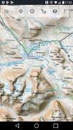
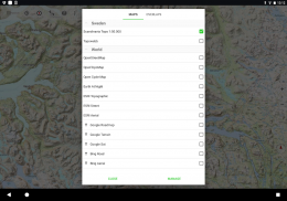
• Топографска карта 1: 50 000 за Скандинавия (Дания, Норвегия, Швеция и Финландия) с планинско засенчване. Карта на терена Lantmateriet + Карта на планината
• Topowebb: Lantmateriet Топографска карта на Швеция
• OpenStreetMaps: Тези пренасочени карти са много полезно допълнение към други слоеве на картата и съдържат много уникални функции
• OpenCycleMaps: Тези карти са идеални за планиране на колоездене (само за PRO потребители)
• ESRI топография
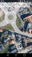
• Въздушни снимки на ESRI
• Пътна карта на ESRI
• Пътна карта на Google (само онлайн достъп)
• Сателитни изображения на Google (само онлайн достъп)
• Карта на терена на Google (само онлайн достъп)
• Bing пътна карта (само онлайн достъп)
• Bing Satellite Images (Само онлайн достъп)
• Земята през нощта
• Наслояване на засенчване на скала
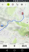
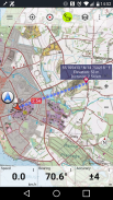
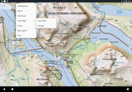
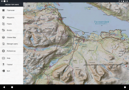
Основни функции за навигация на открито:
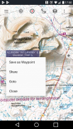
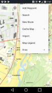
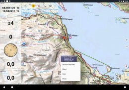
• Създаване и редактиране на пътни точки
• Отидете на навигация по точка
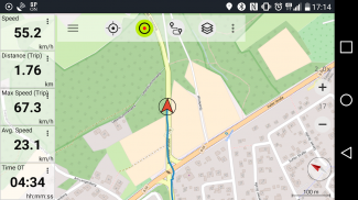
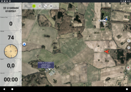
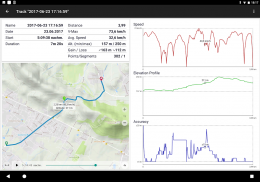
• Проследяване на записа (с профил на скорост, височина и точност)
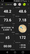
• Tripmaster с полета за измерватели на разстояния, средна скорост, лагер, височина и т.н.)
• Експорт на GPX / KML / KMZ
• Търсене (имена на места, POI, пътища)
• Приспособими полета за данни в Map View и Tripmaster (напр. Скорост, разстояние, компас ...)
• Споделете точки, песни или маршрути (чрез имейл, Whatsapp, Dropbox, Facebook ...)
• Преглед на координатите в Lat / Lon, UTM или MGRS / USNG (Референтна система за военни мрежи / Национална мрежа на САЩ)
• Записвайте и споделяйте песни със статистика и профили на кота
• Завъртане на карта (песен и песен)
• Вземете надморска височина и разстояние, като щракнете дълго върху картата
• Проследяване на възпроизвеждането
• Добавете персонализирани сървъри на карти
• И още много ...
Предлага се за PRO: (Pro функции, налични за покупки в приложение)
• Използване офлайн - не се изисква мобилно покритие. Без такси за роуминг!
• Лесно и бързо масово изтегляне на карти за ОФЛАЙН ИЗПОЛЗВАНЕ (не важи за Google и Bing карти)
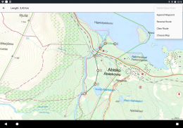
• Създавайте и редактирайте маршрути
• Навигация по маршрута (навигация от точка до точка)
• Внос / износ GPX / KML / KMZ
• Неограничен с точки и песни
• Добавете други сървъри за карти
• Без реклами
Офлайн използване:
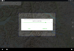
Всички показани полета с карти се съхраняват в кеша. За да кеширате големи площи, трябва да закупите Pro функции.
Използвайте това навигационно приложение за дейности на открито като туризъм, колоездене, къмпинг, катерене, конна езда, ски, каяк, лов, офроуд 4WD обиколки или спасяване на море (SAR).
Добавете персонализирани пътни точки в дължина / ширина, UTM или MGRS / USNG формат с WGS84 дати.
Импортиране / експортиране / споделяне на GPS пътни точки / песни / маршрути в GPX или във формат KML / KMZ на Google Earth.
Предварително заредете БЕЗПЛАТНИ данни за карти за области, които нямат мобилно покритие (Pro функция).
Коментарите и заявките се изпращат на Swedenmaps@atlogis.com
Разгледайте и другите ни приложения за навигация на открито:
https://play.google.com/store/search?q=atlogis
++ Ние не проследяваме потребителската активност и не събираме потребителски данни! ++
Sverige Topo Kartan - Version 7.8.1
(19-05-2025)
Sverige Topo Kartan - APK информация
APK версия: 7.8.1Пакет: com.atlogis.swedenLatest Version of Sverige Topo Kartan
Други версии


 3.98
3.98Apps in the same category

You may also like...


